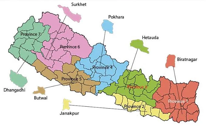
Before 2015, Nepal was a unitary state divided into 5 development regions and 14 administrative zones. Following the promulgation of the new constitution in 2015, Nepal was restructured into a federal democratic republic with 7 provinces and 77 districts.
This restructuring was designed to decentralize power and bring governance closer to the people, recognizing the diverse ethnic, cultural, and geographic differences across the country.
1. Koshi Province (कोशी प्रदेश)
- Capital: Biratnagar
- Location: Far eastern Nepal
- Geography: Ranges from the fertile Terai plains to the high Himalayas, including Mount Kanchenjunga (the world’s third-highest peak).
- Highlights: Tea gardens of Ilam, the Koshi Tappu Wildlife Reserve, and the historic city of Dharan.
2. Madhesh Province (मधेश प्रदेश)
- Capital: Janakpur
- Location: Southeastern Terai (plains)
- Geography: The smallest province by area but the most densely populated. It is characterized by flat, fertile agricultural land.
- Highlights: Janaki Mandir (a major Hindu pilgrimage site), Chhath festival celebrations, and Maithili culture. It is Nepal’s agricultural powerhouse.
3. Bagmati Province (बागमती प्रदेश)
- Capital: Hetauda (official), Kathmandu (working capital)
- Location: Central Nepal
- Geography: Home to the Kathmandu Valley, the country’s political and cultural heart, as well as high Himalayan ranges to the north.
- Highlights: Kathmandu, Patan, Bhaktapur (the 7 UNESCO sites), Langtang National Park, and the popular trekking hub of Sundarijal. It is Nepal’s most economically developed province.
4. Gandaki Province (गण्डकी प्रदेश)
- Capital: Pokhara
- Location: West-central Nepal
- Geography: Famous for the Annapurna massif and the deepest gorge in the world (Kali Gandaki Gorge).
- Highlights: Pokhara, the Annapurna Circuit, Mustang, Manang, and Gorkha. It is the undisputed trekking capital of Nepal.
5. Lumbini Province (लुम्बिनी प्रदेश)
- Capital: Deukhuri (Dang)
- Location: Southwestern Nepal
- Geography: A mix of the Terai plains and the Chure/Pahad hills.
- Highlights: Lumbini (the birthplace of the Buddha), Bardia National Park, and the cultural cities of Tansen and Butwal.
6. Karnali Province (कर्णाली प्रदेश)
- Capital: Birendranagar (Surkhet)
- Location: Mid-western Nepal
- Geography: Nepal’s most remote and least developed province. It is dominated by rugged mountains and the Karnali River (Nepal’s longest river).
- Highlights: Rara Lake (Nepal’s largest lake), Shey Phoksundo National Park, and untouched Tibetan-influenced cultures. It is a paradise for extreme trekking and off-the-beaten-path travel.
7. Sudurpashchim Province (सुदूरपश्चिम प्रदेश)
- Capital: Godawari (Kailali)
- Location: Far western Nepal
- Geography: Borders India to the west and south. Ranges from dense Terai forests to high Himalayan peaks like Api and Saipal.
- Highlights: Khaptad National Park, Shuklaphanta National Park, and the traditional Baitadi and Doti districts.
Frequently Asked Questions
How many provinces are there in Nepal?
There are 7 provinces in Nepal, established by the 2015 Constitution.
What is the largest province by area?
Karnali Province is the largest by area, but it is also the least densely populated.
What is the smallest province by area?
Madhesh Province is the smallest by area, but it has the highest population density.
What is the capital of Nepal?
The capital of Nepal is Kathmandu, which is located in Bagmati Province.
Read next: The Chure Hills: Nepal’s Fragile Lifeline — The low-altitude mountain range that is critical to Nepal’s ecology.
Related districts: Kathmandu, Kaski, Solukhumbu, Surkhet, Dhanusha